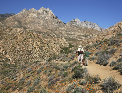
Owens Peak Wilderness (Short Canyon)
Bureau of Land Management, California.
Overview
Owens Peak, the highest point in the southern Sierra Nevada Mountains at more than 8,400 feet, stands near the center of Owens Peak Wilderness. It presides over mountainous terrain with deep, winding canyons, many with rich riparian vegetation fed by bubbling springs. The Sierra Nevada meets the Great Basin and the Mojave Desert here, creating an unusual ecosystem. You'll find creosote bush scrub communities on the bajadas; scattered yuccas, cactuses, flowering annuals, cottonwoods, and oaks in the canyons and valleys; and juniper and piñon woodlands with sagebrush and digger pines on the upper elevations. Mule deer graze beneath golden eagles and prairie falcons. You may see evidence of active human use of this area dating back to prehistoric times.
The Pacific Crest Trail crosses through the area north-south. Other trails leave the PCT to dive off the crest and eventually intersect with roads outside the Wilderness.
For more information about this wilderness, please visit Wilderness Connect.
Leave No Trace
How to follow the seven standard Leave No Trace principles differs in different parts of the country (desert vs. Rocky Mountains). For more information on any of the principles listed below, please visit Leave No Trace, Visit the Leave No Trace, Inc. website.
- Plan Ahead and Prepare
- Travel and Camp on Durable Surfaces
- Dispose of Waste Properly
- Leave What You Find
- Minimize Campfire Impacts
- Respect Wildlife
- Be Considerate of Other Visitors
Rules and Regulations
Motorized equipment and equipment used for mechanical transport are generally prohibited on all federal lands designated as wilderness. This includes the use of motor vehicles (including OHVs), motorboats, motorized equipment, bicycles, hang gliders, wagons, carts, portage wheels, and the landing of aircraft including helicopters, unless provided for in specific legislation. In a few areas some exceptions allowing the use of motorized equipment or mechanical transport are described in the special regulations in effect for a specific area. Contact the agency for more information about regulations.
Nearby Activities
- Camping
- Hiking
- Horseback Riding
- Hunting
- Photography
- Wildlife Viewing
Directions
Access this wilderness from the south via Canebrake Road, off State Highway 178; from the east via U.S. Highway 395 north of Inyokern and along four-wheel drive- recommended routes into Indian Wells Canyon, Short Canyon, Sand Canyon, and No Name Canyon; and from the north via U.S. Highway 395 north Inyokern along Ninemile Canyon Road.

