Salt Creek Wilderness
Fish and Wildlife Service, New Mexico.
The Salt Creek Wilderness now contains a total of 9,621 acres and is managed by the Fish & Wildlife Service's Bitter Lake National Wildlife Refuge. All of the Wilderness is in the state of New Mexico. In 1970 the Salt Creek Wilderness became part of the now over 110 million acre National Wilderness Preservation System.
Migratory waterfowl may consider this a sufficient winter home, but birders will see it as paradise. From October through February, the seasonal wetlands of 24,609-acre Bitter Lake National Wildlife Refuge play host to 5,000 to 20,000 ducks, 10,000 to 30,000 geese, as many as 30,000 cranes, and countless white pelicans and snowy egrets. The uplands, by contrast, are chock-full of quail, roadrunners, pheasant, desert cottontail rabbits, and black-tailed jackrabbits. More secretive but still to be found are mule deer, coyotes, bobcats, and badgers.
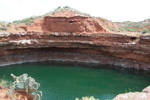
Three tracts make up the refuge: the South Tract is primarily farmland; the Middle Tract holds refuge headquarters and Bitter Lake (named for its water, which tastes sour to many people and often dries up in summer, leaving nothing but a white alkaline bed); and most of the North Tract is designated Wilderness. Salt Creek itself runs through the center of the Wilderness, an area of native grassland, sand dunes, brushy bottomlands, and a northern boundary distinguished by its red-rimmed plateau, all just west of the Pecos River.
Nearby Activities
- Wilderness
Directions
The Salt Creek Wilderness Area is located near Roswell, NM, immediately west of the Pecos River, just north of U.S. Hwy. 70, and east of U.S. Hwy. 285. One public access point, for both foot and horse entry, is at a small parking lot on the north side of Hwy. 70 about 10 mi. northeast of where Hwys. 285 and 70 intersect two miles north of the Roswell Mall and Super Walmart. The highway turnoff is marked by a small wooden sign, Salt Creek Wilderness Area. This access point is at the very southeasternmost corner of the Wilderness. Another similar access point is located at the very western edge of the Wilderness, and can be reached by turning east off U.S. Highway 285 onto One Horse Road. This intersection is about 7.5 mi. north of the Hwys. 285 and 70 intersection. Proceed about 3.75 mi. east on One Horse Road, which will curve toward the northeast and become Cottonwood Road after about 2.75 mi. The parking lot/access point is on the east (right) side of Cottonwood Road about a mile beyond the curve and immediately before the road crosses Salt Creek (usually dry).
