Bitter Lake National Wildlife Refuge
Fish and Wildlife Service, New Mexico.
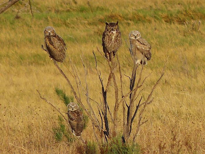
Originally designated the Carlsbad Bird Refuge in 1935, Bitter Lake National Wildlife Refuge first appears as a desolate, barren landscape dotted by occasional stumps, sparse grasses and shrubs. Upon closer examination the various geologic features, bubbling springs and unique desert wildlife make the refuge a true oasis.
Located where the Chihuahuan Desert meets the Southern Plains in southeast New Mexico, Bitter Lake National Wildlife Refuge is one of the most biologically significant wetland areas of the Pecos River watershed system. Established in 1937 to provide wintering habitat for migratory birds, the 24,563-acre refuge plays a crucial role in the conservation of wetlands in the southwestern desert. The refuge’s namesake, Bitter Lake, is a large playa lake which early explorers to the region deemed “bitter” because of its white alkaline salty appearance. Little did they realize that the lake and similar waters support a wonderful diversity of creatures including a marine algae (Bataphora spp.) normally found only in lagoons along the Gulf of Mexico. The refuge supports approximately 1,200 acres of wetlands that include more than 70 sinkholes, large moist-soil managed impoundments, riverine habitats, ciénegas, and fresh to brackish springs.
The wetlands attract more than 26,000 sandhill cranes, more than 50,000 snow geese and ducks during migration, as well as a variety of wading birds shorebirds such as great blue herons, egrets, white faced ibis, snowy plovers, least terns, black-necked stilts, and avocets.
Situated along the floodplain of the winding Pecos River, the refuge is dotted by sinkholes created by groundwater from paleozoic aquifers dissolving the gypsum deposits in the soils above. Water bubbles to the surface along the refuge’s western edge from the San Andreas limestone formation, providing water and habitat for several resident threatened and endangered invertebrate, fish, and plant species. The Pecos River itself has undergone many changes including a New Mexico River Ecosystem Initiative project that reconnected an old oxbow to improve water quality; improve habitat for the threatened Pecos bluntnose shiner; attract more birds, mammals, reptiles, fish; and remove invasive plants like saltcedar.
Several significant designations honor Bitter Lake National Wildlife Refuge. It is recognized as a Globally Important Bird Area, offering vital habitat and refuge for over 350 species of birds; as a National Natural Landmark and Research Natural Site designated by the National Park Service, which recognizes the more than 70 unique natural sinkhole depressions formed by subsurface water percolating through the San Andreas limestone, saline artesian lakes, and shrub-grasslands; and as a Ramsar International Wetland of Importance site. This is a treaty that promotes wetland conservation throughout the world. These refuge wetlands and ciénegas helped designate the area as the first Ramsar site in New Mexico, the second Ramsar site in the entire Chihuahuan Desert Ecoregion, and one of the handful of Ramsar sites in the Interior West. In addition, Salt Creek Wilderness Area, an undeveloped and unimpaired 9,621-acre Congressionally designated wilderness area, graces the northern section of Bitter Lake National Wildlife Refuge. All of these designations recognize the tremendous value of this transitional area between the northern end of the Chihuahuan Desert and southwestern corner of the Southern Great Plains.
The early foundation of Bitter Lake National Wildlife Refuge was built by hard working young men in the Civilian Conservation Corps (CCC) in the late 1930s as part of a Depression-era public works program initiated by President Franklin D. Roosevelt that worked to rebuild and conserve our nation’s public lands. The CCC camp built the original office, quarters, garages, levees, water control structures, water delivery systems, and impoundments, several of which are still intact and in use today.
Nearby Activities
- Auto Touring
- Biking
- Birding
- Hiking
- Horseback Riding
- Hunting
- Interpretive Programs
- Photography
- Visitor Center
- Wildlife Viewing
Directions
Bitter Lake National Wildlife Refuge is located 7 miles northeast of Roswell, in Chaves County, New Mexico.
From Roswell (south side), take US 380 (Second Street) east about three miles to Red Bridge Road. Follow Red Bridge Road north to Pine Lodge Road and travel east to the refuge entrance gate.
From Roswell (north side), take US 285 (Main Street) north to Pine Lodge Road. Take Pine Lodge east about 6 miles to the refuge entrance.
The coordinates are 33.456038, -104.401680. The elevation level at the refuge is 3,526 feet.

