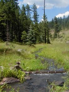
Coronado Trail Scenic Byway
Department of Transportation.
Drive through high desert and forests, and see former Native American footpaths first used as horse paths by Conquistadors and prospectors, then as wagon trails for pioneers. While admiring the scenic beauty, imagine nomadic tribes of hunters, gatherers, trappers, outlaws, homesteaders, lumberjacks, and ranchers living along the byway.
Directions
Getting to the Byway:
Flagstaff, AZ
- Get on I-40 east toward Gallup.
- Turn right on Hwy. 77 south toward Show Low.
- Turn left on U.S. 180 east.
- Turn left on Hwy. 61 north to St. Johns.
- Turn right on U.S. 191 south to Springerville where the byway begins.
Gallup, NM
- Get on I-40 west toward Flagstaff.
- Turn south on U.S. 191 to St. Johns.
- Turn left and continue on U.S. 191 to Springerville where byway begins.
Phoenix, AZ
- Take I-10 east toward Tucson.
- Merge onto US-60 east toward Mesa.
- Follow US-60 until you reach Springerville where the byway begins at US-191.
Phoenix, AZ
- Get on Hwy. 87 north to Payson.
- Turn right on Hwy. 260 east to Show Low.
- Turn left on U.S. 60 east to Springerville where the byway begins.
Phoenix, AZ
- Take I-10 east toward Tucson.
- Merge onto US-60 east toward Mesa.
- Follow US-60 until you reach Springerville where the byway begins at US-191.
Phoenix, AZ
- Get on Hwy. 87 north to Payson.
- Turn right on Hwy. 260 east to Show Low.
- Turn left on U.S. 60 east to Springerville where the byway begins.
Tucson, AZ
- Get on I-10 east toward El Paso.
- Turn right on U.S. 191 north.
- Follow until you reach Morenci where the byway begins.
Navigating the Byway:
* The byway starts in the city of Morenci, Arizona, at the junction of U.S. Hwy. 191 and Burro Alley.
* Drive north on U.S. Hwy. 191 to Alpine.
* Drive north on U.S. Hwy. 191 to E. Main St. in Springerville.
* Drive west on E. Main St. to U.S. Hwy. 180/S. Mountain Ave. where the byway ends.
