Volcanic Legacy Scenic Byway - California
Department of Transportation.
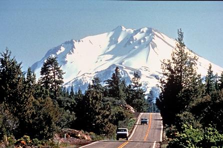
Explore the wonder and beauty of a dramatic volcanic landscape from Crater Lake in Oregon to Lassen Peak in California. Encounter the ancient natural forces that shaped exquisite mountain lakes. Along with spectacular scenery, including the world-famous Mount Shasta, you'll enjoy history, charming towns and extraordinary recreational and cultural opportunities.
Directions
Getting to the Byway:
###From Sacramento, CA### * Get on I-5 north toward Redding. * Turn right on CA-44. * You will join the byway at the intersection of CA-44 and CA-89.
Navigating the Byway:
The California Volcanic Legacy corridor is an extension of the Oregon Volcanic Legacy All-American Road, which reaches the Oregon/California border via Highway 97, three miles north of the town of Dorris. From this point, you can choose to go east toward the Modoc section of the byway, or south on the Shasta section, continuing to the Lassen section.
The Modoc Section
- From Highway 97, near the California / Oregon border, head east on Highway 161 for roughly twenty miles, past the Lower Klamath Wildlife Refuge, to the junction with Highway 139.
- From the junction of Highway 161 and 139, head southwest - you are now at the beginning of the Modoc section. From the junction of Highway 161 and 139, head south for roughly 3.5 miles. The byway turns onto Main Street in the town of Tulelake.
- Continue on Main Street until you reach the junction of Main Street and East-West Road. Head west on East-West Road for 4.4 miles where you will reach Hill Road.
- Head south on Hill Road for 18.9 miles, past the Tule Lake National Wildlife Refuge.
- At the junction of Hill Road and Main Monument Park Road, head
east on Monument Road for 8 miles to the Lava Beds National
Monument Visitor Center. The Monument marks the end of this leg of
the byway.
Please Note: For adventurers, there are forest roads that lead south from Lava Beds National Monument to reconnect with the byway on Highway 89, roughly 15 miles east of the town of McCloud. However, these roads are quite narrow and rough in places. Buses or RVs should not take this route. The forest roads are closed in the winter.
The Shasta Section
- On Highway 97, continue south from the Oregon/California border, through Klamath National Forest, Butte Valley National Grasslands, Shasta-Trinity National Forest, and Mt. Shasta Wilderness until you reach the junction with I-5.
- From the I-5/Highway 97 junction, continue south from Weed to Highway 89, south of the town of Mt. Shasta.
- Head east on Highway 89, past McArthur-Burney Falls Memorial State Park and Lake Britton.
- Then, head south on Highway 89 to the Hat Creek Valley portion of the Lassen National Forest.
The Lassen Section
Portion of Highway 89 from north entrance of Lassen Volcanic National Park to its junction with Highway 36 near Mineral.
- From here the byway takes two alternate routes which converge near the town of Chester:
- Highway 36 from Highway 36/89 junction west of Chester to junction with Highway 147 near town of Westwood.
- Highway 89 from Highway 36/89 junction west of Chester to its junction with Highway 147 near town of Canyondam.
- Continuing on Highway 147 along east shore of Lake Almanor, passing through the town of Clear Creek and on to its junction with Highway 36 near the town of Westwood.
- Highway 36 from its junction with Highway 147 near Westwood to its junction with Highway 44 and
- Highway 44 from its junction with Highway 36 to its junction with Highway 44/89 near the town of Old Station. This completes the byway loop.