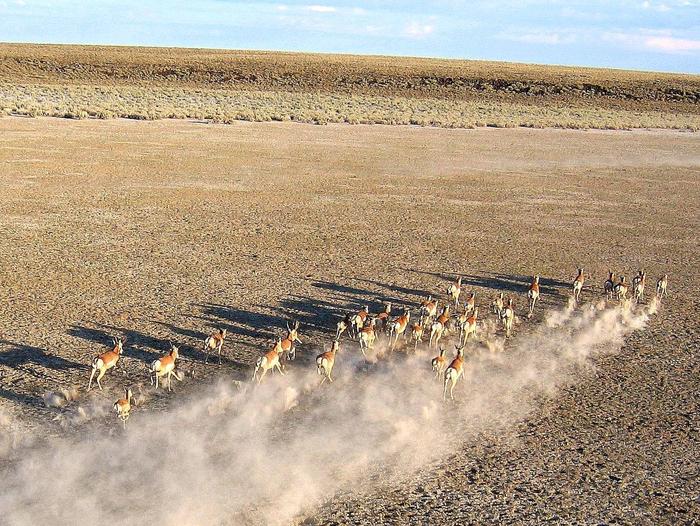
Sheldon National Wildlife Refuge
Fish and Wildlife Service, Nevada.
Sheldon National Wildlife Refuge was established in 1931 to: (1) provide habitat for pronghorn, the primary species, and populations of native secondary species (e.g., mule deer, sage-grouse, and song birds) in such numbers as may be necessary to maintain a balanced wildlife population; (2) conserve listed endangered or threatened fish, wildlife, and plants; and (3) use as an inviolate migratory bird sanctuary. Today, the Refuge protects 572,896 acres of wildlife habitat in the northwestern corner of Nevada and is home to over 270 species of wildlife.
The high desert is characterized by wide-open spaces and a variety of landforms. The two most common landforms include narrow canyons that empty into rolling valleys with no drainage outlets to the ocean, and broad flat tables that end abruptly in vertical cliffs. The elevations of these landforms range from a high of 7,294 feet on Catnip Mountain, to a low of approximately 4,200 feet on the northeastern boundary. The area generally decreases in altitude from west to east.
The Refuge currently represents one of the last reasonably intact examples of a sagebrush-steppe ecosystem in the Great Basin. It provides a variety of critical habitats for a host of species endemic to sagebrush-steppe, including pronghorn, mule deer, greater sage-grouse, pygmy rabbit, migratory birds, desert fishes, and a range of rare plants and invertebrates.
Nearby Activities
- Auto Touring
- Biking
- Birding
- Boating
- Camping
- Fishing
- Hiking
- Historic & Cultural Site
- Horseback Riding
- Hunting
- Interpretive Programs
- Off Highway Vehicle
- Photography
- Wildlife Viewing
Directions
From Reno (325 miles) via Lakeview, Oregon (best road conditions—paved roads):
1) Follow Highway 395 north for 235 miles to Lakeview, OR (gas, groceries, restaurants, hotels, hardware, vehicle repairs, hospital)
2) Continue following Highway 395 north from Lakeview for 5 miles.
3) Following signs for the Warner Mountain Ski area, Adel and Winnemucca, Nevada, turn east onto Highway 140.
4) Follow Highway 140 east for 85 miles.
5) Follow signs for Sheldon National Wildlife Refuge Dufurrena Field Station, turning south onto Virgin Valley Road.
Alternate Route From Reno (224.5 miles) via Alturas and Cedarville, California (paved and graded gravel roads—NOT MAINTAINED IN WINTER):
1) Follow Highway 395 north for 181 miles to Alturas, CA (gas, groceries, restaurants, hotels, hardware, and vehicle repairs).
2) Continue following Highway 395 north from Alturas for six miles to the junction with Highway 299.
3) Following signs for Cedarville, turn east on Highway 299
4) Follow Highway 299 east for 16.5 miles.
5) Continue east through Cedarville (gas, restaurant, grocery, hotels, towing service, health clinic) on Highway 299 (becoming Nevada Route 8A- graded gravel road NOT MAINTAINED IN WINTER).
6) Follow Highway 299/ Road 8A for 21 miles to Road 8A and Road 34 Junction and signs for SHELDON WILDLIFE REFUGE. From this point you have two options to access the Refuge.
Option A: Follow Road 8A east from junction for 18 miles to Refuge southwest entrance
OR Option B: Follow Road 34 north from road junction for 22.7 miles to Refuge west entrance.
From Winnemucca (124 miles) via Denio Junction, Nevada (28 miles):
1) Follow signs for Melarkey Street, Highway 95, and Veterans Memorial Highway.
2) Follow Highway 95 north for 31.5 miles.
3) Follow Following signs for Denio, turn west onto Highway 140.
4) Follow Highway 140 west for 65.5 miles, past Leonard Creek Rest Area (30 miles) to Denio (groceries, restaurant, hotel)
5) At Denio turn west and continue on Highway 140 for 25 miles.
6) Follow signs for Sheldon National Wildlife Refuge Dufurrena Field Station, turning south onto Virgin Valley Road.
7) Follow Virgin Valley road 1 mile to the Refuge Headquarters 8) Continue 1.5 miles to the Virgin Valley Campground.

