Lower Deschutes River Boater Pass
Lower Deschutes Wild and Scenic River
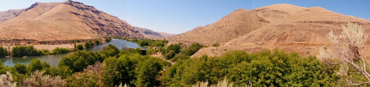
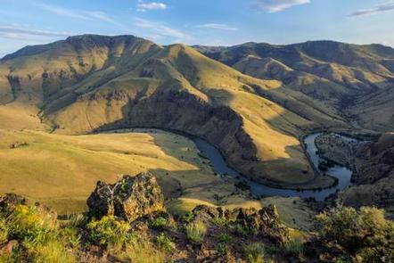
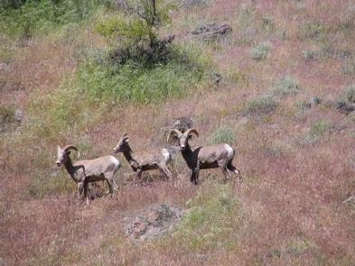
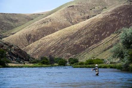
It’s time to discover the wonders of the Lower Deschutes River! Float through steep walls of basalt cliffs to enjoy world-class fishing, exciting whitewater and beautiful scenery on this spectacular river. Every day offers opportunities to experience a diverse community of fish, wildlife, vegetation, and the incredible geologic and cultural history of the region.
The Deschutes River begins high in the Cascade Mountains and travels 252-miles north to the Columbia River. The last 100 miles of the river’s path are known as the Lower Deschutes River, which is designated as both a Federal Wild and Scenic River and an Oregon Scenic Waterway.
The Lower Deschutes has a unique flow that is fairly uniform compared to other similar rivers. The annual fluctuation between flows is small due to the many springs that feed the river in the upper reaches, and the effects of the Pelton Reregulation Dam, which delivers a uniform flow for the last 100 miles.
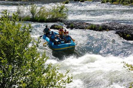
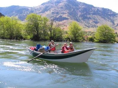
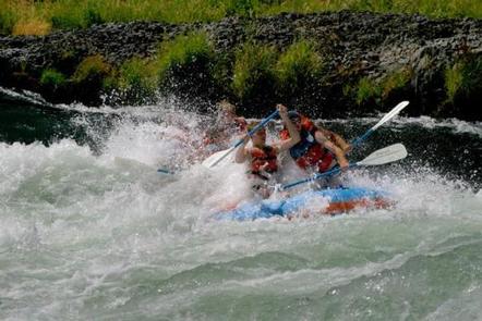
Whitewater rafting, kayaking, drift and jetboating are all available on the Lower Deschutes River. For thrilling whitewater, the most popular section is the 10 mile day-float from Harpham Flat to Sandy Beach, with rapids rated up to Class III+. Anglers from all over the world are drawn to the river for the abundant trout and steelhead fishing. The river also offers opportunities for overnight boating trips, drive-in camping, hiking, mountain biking and hunting.
The Lower Deschutes uses a Boater Pass system to protect it from excessive human impacts. Boater Passes are required year-round for day and overnight use for anyone using a watercraft or floating device for transport. As part of that protection plan, we also ask you to learn and practice “Leave No Trace” ethics and leave no trace of your visit.
If you plan to camp overnight in a drive-in campground, be sure to arrive early to get a campsite, as no reservations are taken and campsites are available on a first-come, first-served basis.
The Lower Deschutes has a rich cultural history, providing sustenance for thousands of years to the Warm Springs and Wasco people moving seasonally through the area. In the 1800s, due to increasing pressure from settlers, many moved to the lands now known as the Warm Springs Reservation, which borders much of the west side of the Lower Deschutes. Members of the Confederated Tribes of Warm Springs retain their fishing rights and can be seen dip net fishing the traditional way on platforms over the river just below Sherars Falls.
The elevation drops from 1,393 feet at Pelton Dam to 160 feet at its confluence with the Columbia River. The most significant drops in gradient are Sherars Falls (River Mile 44), with a vertical drop of 15 feet, and Whitehorse Rapids (River Mile 75), with a gradient of approximately 35-40 feet over one mile.
The Lower Deschutes River is managed cooperatively by three agencies: Prineville District Bureau of Land Management; the Confederated Tribes of Warm Springs; and Oregon Parks and Recreation Department.
Notifications and Alerts
The BLM Prineville District plans to implement a prescribed fire on 20 hand piles on the Windy Flat camping site South of Maupin (about 10 miles) and West off of the Deschutes access road.
Ignition is planned for the week of April 14 (likely on Wednesday April 16). Operations will begin as early as 10:30 AM and will continue until ignitions are complete and/or conditions become unfavorable.
This treatment is part of the Windy Flat Fire (August 2024) rehab and is intended to eliminate hazardous fuels and to manage the Russian Olive (invasive species) in the wild and scenic Deschutes River corridor, and to maintain, promote, and restore the health and integrity of Cottonwood, Hackberries and other riparian vegetation.
What does this mean for you?
- During prescribed burns, smoke may settle in low-lying areas overnight.
- If you have heart or lung disease, asthma, or other chronic conditions, ask your doctor about how to protect yourself from smoke.
- Go to Central Oregon Fire Info to learn more about smoke safety and prescribed burning in Central Oregon.
Contact Prineville BLM at 541-416-6700 for any further questions.
Permit & Season Information
Boater Passes are required year-round for anyone using a watercraft or any other floating device as a means of transport on the Lower Deschutes River. The Lower Deschutes is divided into 5 segments. The Boater Pass is only valid for the segments and dates for which it is issued and for only one group. Each person may be named as group leader or alternate leader on only one Limited Entry Pass at a time.
Access is restricted to a limited number of boaters on:
Segment 1: Friday, Saturday and Sunday, May 15 - September 15
Segment 2: No Limits
Segment 3A & 3B: No Limits
Segment 4: 7 days a week, May 15 - October 15
Learn more about the 5 unique Lower Deschutes River Segments.
Limited Entry Pass Availability
Passes become available in a batch rolling release as follows:
• 26 weeks in advance - 50% of passes released
• 4 weeks in advance - 30% of passes released
• 1 week in advance - 20% of passes released
Need to Know
When purchasing a Boater Pass on this river, I certify and understand that:
- Each person may only be named as trip leader or alternate leader on one Limited Entry Boater Pass at a time;
- Once purchased, the trip leader and alternate leaders cannot be changed;
- The group leader or an alternate leader named on the Boater Pass must be present the entire trip;
- This Boater Pass is for a private trip unless the trip will be guided by a commercial outfitter currently authorized by the Bureau of Land Management to operate on this river;
- The Boater Pass is only valid for the segments and dates for which it is issued and for only one group;
- There is group size limit of 16 people in Segments 1, 3B (Pine Tree to Macks Canyon) & 4; and 24 people in Segment 2 & 3A (Buckhollow to Pine Tree), regardless of the number of Boater Passes purchased by the group.; and
- Boater Pass fees are non-refundable.
Securing your permit also comes with agreement from you and your guests to the following requirements:
Campfire/Smoking Restrictions – due to extreme fire danger
June 1 - October 15: no open fires, charcoal fires or portable propane fires are allowed. Commercially manufactured gas or propane camp stoves and shielded lanterns are allowed. Smoking is allowed in non-public buildings, vehicles, in a boat on the water, or while standing in the water.
October 16 – May 31: fires must be contained in a metal fire pan or similar metal container with sides at least 2 inches high, and is elevated above the ground. All charcoal, ash and unburned contents of a campfire must be carried out. A BLM-provided metal campfire ring may be used in lieu of a fire pan.
Trash/Human Waste Disposal
Pack out all trash. Do not use vault toilets for trash disposal. Overnight boaters must carry and use an approved RV dump station or SCAT machine compatible human waste pack out system. Plastic bag systems are prohibited except for commercially available human waste bags (WAG bags). Used human waste bags must be carried in a sealed, leak-proof container and disposed of according to manufacturer instructions. A human waste system must be set-up and available for use as soon as practical upon arrival at campsite.
Motorized Boating
Motorized boating is allowed in Segment 3 and 4. Motorized boating is not permitted in Segment 3 from June 15 -September 30 or in Segment 4 on alternate weekends (Thursday - Sunday) from June 15 - September 30. See Segment 4 Motorboat Schedule .
Camping Information
• Private property, including the Warm Springs Reservation except by permit, is closed to public use. No trespassing.
• Camping at boat-in sites is limited to 4 consecutive nights except when camping w/ motorized watercraft.
• When motorized watercraft are allowed, camping in one campsite is limited to 9 consecutive nights from May 15 - October 15. After these limits are reached, ALL camping equipment and personal property must then be removed and cannot be relocated within 1/4 mile of the same site for 14 days.
• Quiet hours are from 10:00 p.m. to 7:00 a.m. Generators, amplified music and other excessive or loud noise is prohibited within this time frame.
• Camping is not allowed on islands.
Observe all local, state and Federal laws and regulations. See the complete list of the Rules & Regulations for the Lower Deschutes River (PDF).
Additional Passes and Permits
- Warm Springs Tribal Permit: A Warm Springs Tribal permit is required for use of Harpham Flat and Sandy Beach access points.
- Aquatic Invasive Species: Ensure all boats are clean, drained, and dry to avoid spreading aquatic invasive species. An Oregon Waterway Access Permit is NOT required on the Lower Deschutes River (exemption for a federally designated river for which a separate fee system is in place).
- Moody Island Pass: To access Moody Island near Heritage Landing, self-pay at Heritage Landing boat launch. A Deschutes River Boater Pass is not required below Moody Rapids and to access the Island across from Heritage Landing.
Fee Policy
Reservation Fee
A $6.00 non-refundable reservation fee is required for each Boater Pass purchased.
Recreation Fees
Each person boating on the river must also pay a Recreation Fee in the amount of $5.00 per person per day.
Cancellation Policy
Cancellation Policy
If you have not printed your boater pass, you may cancel it online without a refund. Cancelled spaces will be returned to the available quota immediately. To cancel your Boater Pass, please go to your current reservations with Recreation.gov and follow the instructions. If you have already printed your boater pass, contact the BLM at 541-416-6700 to cancel.
Change Policy
Once purchased, no changes to the boater pass are possible. Alternate leaders must be listed at the time the Boater Pass is purchased.
Contact Information
Mailing Address
3050 NE 3rd Street Prineville OR 97754
Mailing Address
PO Box C Warm Springs OR 97761
(541) 553-1161
Mailing Address
1645 NE Forbes Road, Suite 112 Bend OR 97701
(541) 388-6211
Phone Number
541-416-6700